Hello old friend
Geez, has it been almost 6 months since I posted on this thing? I better get caught up then, ala Memento style! Over the next few days (weeks?) I'll post stuff that happened in reverse order, not because of any creative inclination, but simply beacuse I'm worried that I'll forget what's in my short-term memory, as I usually do. So here we go...
Last weekend:
With Gina and Sagada away at VA beach, I slipped into bachelor mode and hooked up with my two buddies Lemond and DeSalvo for some wild times. On Saturday I downloaded the "Hills of Purcell" cue sheet from PPTC and headed out the door for some road miles. The ride called for 42 miles, but I only made it to mile 23 before I fell victim to a bad cue. The cue sheet says to turn left on Fairview from Lake Jackson Dr. It should have said left on Wilmington. Unable to pick up the route and already low on water, I decided to backtrack to get home. 40 miles is 40 miles, and it was still a good ride. The climbs around Clifton can be a workout, even with gears. And the downhills will have you grinning as you hit 40mph. Ahh, the thrill of the road. The drivers there are cool too. I guess they're used to bikes on the road and don't honk at cyclists even though the roads can be narrow. Contrast this with one of the roads immediately next to my neighborhood, which is just as narrow and fast, but I get honked at twice in a one mile stretch.
On Sunday, AteMrYeats (aka Skinny Chris) and I (aka Guy-who-is-probably-skinnier-that-Skinny-Chris) hit the GWNF for some 'splorin on trails that neither of us had been on. We parked at Little Fort campground and rode the Massanutten trail (orange blaze) to a point just before Edinburg Gap and then returned using an ATV trail. Crouse and others had done this loop the week before so I knew it wasn't going to be the hike-a-bike hell that was reminiscent of another trip up there. There are a number of ways to get from the campground to Woodstock Tower where the orange trail begins. We chose the worst way up.

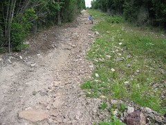
(photo by ChrisH)
The hike-a-bike under powerlines is on quite possibly the steepest grade that I've ever walked up. In my life. The picture doesn't do it justice. Once the hiking was over, we were treated to some of the best ridge riding in the area. The ~6 miles from Woodstock Tower to Edinburg Gap had a little bit of everything-- technical rock gardens, swoopy fast singletrack, and bear poop. Yes, lots of bear poop. I don't think people ride that trail much so the bears think they can sh!t anywhere they want. The only thing missing from this trail was a long singletrack descent to finish it off. However, the ATV trail we took is literally a six-mile downhill all the way back to the cars with a few little kickers from which to catch air. I'm surprised that this trail isn't a popular as the standard "Bear Wallow" loop. In a lot of ways, it's better. A couple of pics:
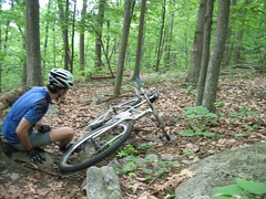
Me, taking a break after crashing...

(photo by ChrisH)
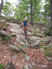
Chris, and a few small rocks

(photo by me, using ChrisH's camera)
In a few weeks (when the Wakefield races are over), I want to put together a ride that will cover the length of the orange trail from Mudhole Gap to Edinburg Gap. I now know that ~10 mile section of ridge is ridable. I imagine it will be an eipc to rival the Southern Traverse, and without the long road section at the end. Post up here if interested.

3 Comments:
I'm not interested so don't ask me. Undoubtedly it'll be hot, which means sweat, which means icky. Homey don't do icky.
12:35 PM
South on the ridge from Mudhole to Edinburg is an excellent idea. Do you know a rideable route to the ridge near Mudhole Gap?
11:35 AM
IMHO, I think the best way to ride this is to park at Little Fort and do a "figure 8" loop that puts you back at the cars mid-ride for supplies and such. From Little Fort, climb the road to woodstock tower then head south on the ridge, take the ATV trail back to the cars (a nice 6 mile downhill), repeat the climb to the tower, head north on the ridge and take the road back to the cars again. This way, you get mid-ride sag and don't have to do 13 road miles all at once.
1:15 PM
Post a Comment
<< Home